The Harmonic Earth Grid
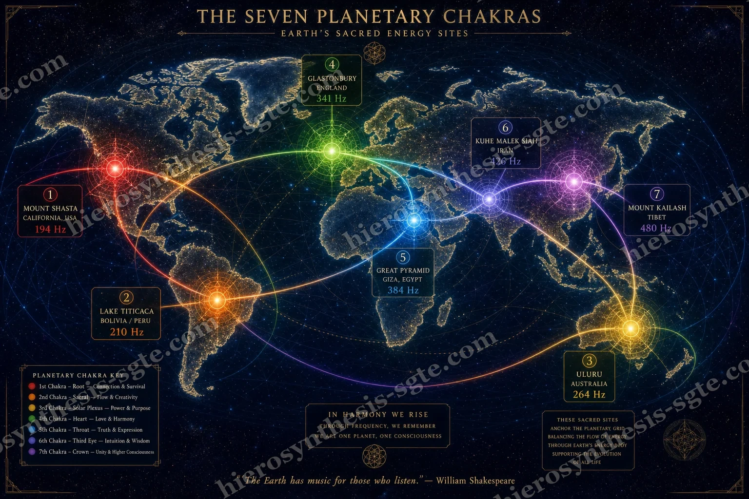
Seven famous sites, one for each of the body, pinned at their real coordinates. The colour washed between them is a blend: every point on Earth takes a mix of the seven, with the nearest counting for most. Hover — or, on a phone, tap — anywhere on the map to read the mix at that point.
A map that colours the whole Earth by which of seven sacred sites is nearest. Two very different things are stacked here and the page keeps them apart: the blending maths, which is ordinary and checkable, and the site-to-chakra-to-frequency correspondence, which is a symbolic assignment.
What it computes
- 01Fix seven nodes at their published coordinates — Shasta, Titicaca, Uluru, Glastonbury, Giza, Kuh-e Malek Siah, Kailash — each carrying an assigned chakra, colour and frequency.
- 02For every pixel of the map, measure the great-circle distance from that point to all seven nodes: the shortest path along the curve of the globe.
- 03Weight each node by
1 / distance^2.4, so a node twice as far away counts far less than half as much. Divide by the total so the seven weights add to 1. - 04Blend the seven colours and the seven frequencies in those proportions, and paint the result. That is the whole colour field — no data beyond the seven numbers you can see.
- 05Draw the world's coastlines over the top, purely so you can tell where you are.
How to read it
The hover readout — a tap does the same on a touch screen, and pins it in place — is the honest part: it shows the blended frequency and the top three nodes with their percentages, so you can always see what is producing a colour. A place that reads Heart 54% · Throat 22% is simply nearer Glastonbury than Giza. Read the map as a picture of which of seven ideas is closest to a place, not as a measurement of the ground.
What it does not claim
Nothing here is geophysics. The coordinates are real and the interpolation is standard mapping arithmetic, but the assignment of a chakra and a frequency to a site is a symbolic correspondence — Tier C — held in the earth-grid tradition and not measured by anyone. No instrument at Uluru reads 264 Hz. The smooth field also implies a continuous quantity where there is none: the seven values are labels, and the space between them is arithmetic, not evidence.
The key to the colours above. Left to right: root to crown, 194 to 480 Hz — the same order the seven run up a spine, and the same order red runs to violet in a rainbow. That rhyme between the sound ladder and the colour ladder is the reason the map can be coloured at all.
What do the words on this page mean?
Nine terms carry the whole map. None of them should send you anywhere else.
in the Indian tradition, one of seven energy centres running up the spine from base to crown — each tied to a part of the body, a feeling, a colour and a sound. This page borrows the seven and pins them to places on Earth instead of places on a person.
one of the seven sites. Each is a real, named location with real coordinates; what is asserted is the pairing of that site with that chakra, not the site itself.
hertz — cycles per second. 194 Hz means something vibrating back and forth 194 times a second. Nothing at these sites has been measured doing that; the figure is an assigned correspondence, in the same way a colour is assigned.
the single syllable traditionally chanted at a chakra — LAM at the base, VAM, RAM, YAM, HAM, and OM at the crown. Sanskrit, and much older than this map.
the character the node is read as — Survivor, Creator, Warrior, Lover, Communicator, Seer, Sage. A one-word portrait of what that centre is for.
which organs and tissues the same chakra governs in the body, so a place and a body part end up sharing a name.
the wash of colour over the map. It is not satellite data. Every point takes a blend of the seven node colours, weighted so nearer nodes count for more — the same arithmetic a rainfall map uses to fill in the gaps between weather stations.
how much each node contributes at the point under your cursor — on a touch screen, tap the map and the same readout pins itself there. “Root 62% · Sacral 21%” means the blend there is mostly Shasta with some Titicaca in it.
the shortest way between two points measured along the curve of the globe, not through it — what an aeroplane flies. It is what decides which nodes count as near you.
The seven nodes
Click a card or a pin to open it. Every field on the panel is defined in the words drawer above. Under each card is a deep drawer holding the real place — its ground, its documented record, its lore, and the honest line where fact ends — so each node can be dug into on its own.
What is actually at Mt. Shasta?
A volcano — a live one. Shasta is a stratovolcano, a cone built up from layer after layer of lava and ash, standing about 4,300 metres tall at the south end of the Cascade Range in northern California. By volume it is one of the largest volcanoes in that whole chain. Its last eruption was only a few centuries ago, and geologists list it among the volcanoes most likely to erupt again — dormant, not dead. If the Root is the chakra of raw survival, the mountain chosen for it is, at least, genuinely dangerous ground.
Long before any grid was drawn, the mountain was holy to the peoples living around it — the Shasta, Wintu, Achumawi and Modoc among them. Wintu tradition ties the mountain to creation itself, and a spring on its slopes is still used ceremonially today. That reverence is documented, living, and much older than anything else on this card.
The modern legends start with a novel: in the 1880s a local teenager named Frederick Spencer Oliver wrote A Dweller on Two Planets, which planted the idea of survivors of a lost continent, Lemuria, dwelling inside the mountain. In the 1930s Guy Ballard said he met an ascended master on its slopes and founded the “I AM” movement on the strength of it. Today the legend has a name for the city inside — Telos — and the earth-grid literature crowns the whole stack by making Shasta the planet's Root, its first .
The volcano, its geology, and the native peoples' reverence are documented fact. The city inside is not: volcano interiors are routinely imaged by the way earthquake waves pass through them, and Shasta's shows rock and magma plumbing, as volcanoes do. The Root assignment is a correspondence — the lists that make it, and this page, inherit it rather than measure it.
What is actually at Lake Titicaca?
A sea in the sky: Titicaca sits about 3,800 metres up in the Andes, straddling the Peru–Bolivia border. It is the largest lake in South America and the highest of the world's great navigable lakes — high enough that the air holds noticeably less oxygen than at sea level. It is fed by rain and glacier melt and loses most of its water not through rivers but straight up, to evaporation.
The southern shore held the capital of the Tiwanaku civilisation, which flourished for roughly five centuries before 1000 CE and whose stone architecture still stands. The Inca who came later set their own origin story here: the creator god rose from the lake, and the first Inca emerged on the Island of the Sun to found the royal line. This is not only story — archaeologists diving near that island have raised carved stone boxes from the lake bed holding gold and shell figurines, real offerings lowered into the water centuries ago.
The earth-grid literature makes Titicaca the planet's Sacral centre — the chakra of creation, birth and flow — and it is easy to see the reasoning: a birth-of-the-world myth, water at impossible altitude, offerings sunk in it for a thousand years. Some versions of the literature add great serpent-currents of energy said to cross here.
The lake, the altitude, the ruins and the recovered offerings are documented. The origin story is real as a story — a myth the Inca themselves told, which is a fact about them, not about the water. The Sacral role and the currents are correspondence, held at like every pairing on this page.
What is actually at Uluru?
One enormous body of sandstone rising 348 metres out of the central Australian desert — and that is only the exposed corner. The rock layers were laid flat as sand around 550 million years ago, then folded nearly vertical, so the stripes you see on Uluru run up and down: you are looking at the turned-up edge of a slab that continues far beneath the plain. Fresh, the stone is grey; the famous red is rust, a skin of iron oxide weathered onto the surface.
Uluru belongs to the Anangu, whose ancestors have lived in central Australia for tens of thousands of years. In their law, Tjukurpa, the rock's caves, scars and waterholes each carry their part of the founding stories — the landscape is the record. Australia returned the land to Anangu ownership in 1985, and in 2019 climbing the rock ended for good, at their long-standing request.
The earth-grid lists make Uluru the planet's Solar Plexus — the will centre, the fire in the belly of the world — often pairing it with the domed rocks of Kata Tjuta nearby. The image is striking: a single red monolith at the centre of a continent, standing in for the body's seat of power.
The geology is documented, and the Anangu tradition is real and living — but it is their own, it is taught on their terms, and it says nothing about chakras. The Solar Plexus role is a Western overlay placed on the rock from outside; the respectful reading keeps the two separate, and this page files the overlay as claim, not as Anangu teaching.
What is actually at Glastonbury?
A terraced green hill — the Tor — rising from the Somerset Levels in south-west England. The Levels were marsh and open water into the Middle Ages, so the Tor once stood almost as an island above the wetlands. The tower on its summit is the surviving piece of a fourteenth-century church of St Michael; the origin of the terraces ringing the slopes is still debated, farming being the plain explanation and a processional maze the romantic one.
Below the Tor stood Glastonbury Abbey, one of the oldest and richest monasteries in England until Henry VIII dissolved it in 1539. In 1191 its monks announced they had found the grave of King Arthur and Guinevere in the abbey grounds — a claim most historians read as fundraising, coming as it did after a fire had ruined the abbey in 1184 and pilgrim income was badly needed. Around the abbey grew the legends of Joseph of Arimathea, the Holy Grail, and the winter-flowering thorn.
Modern Glastonbury is the capital of the earth-mysteries movement. Alfred Watkins's 1920s idea of and John Michell's 1969 The View Over Atlantis met here, and a famous claimed alignment — the St Michael line — is drawn through the Tor. The earth-grid lists make Glastonbury the planet's Heart, often twinned with nearby Shaftesbury.
The abbey, the Tor, the dissolution and the 1191 announcement are documented; the grave itself is a medieval claim historians doubt. The alignments are harder than they look: statisticians have shown that random points scattered on a map as crowded with old sites as England will produce straight lines by accident, so a line alone proves little. The Heart role is correspondence.
What is actually at Giza?
A limestone plateau on the west bank of the Nile, at the desert edge of modern Cairo. West mattered: it is the side of the setting sun, which the Egyptians read as the side of the dead, and so the side for tombs. The stone under the pyramids is the same stone they are mostly built from, quarried close at hand.
The Great Pyramid was raised for the pharaoh Khufu around 2560 BCE from roughly 2.3 million blocks, and was originally cased in polished white limestone that has almost all been stripped away. Its sides face true north with an error of a few hundredths of a degree — sharper than most modern buildings manage. The excavated town beside the plateau shows who built it: organised, rotating crews of paid labourers with bakeries, breweries and medical care — not the slave gangs of legend.
The earth-grid lists make Giza the planet's Throat — the voice of the world — and no site on this map carries a taller stack of other claims besides: star-shaft alignments, lost-civilisation datings, chambers tuned to sacred sound. One modern physics paper found the pyramid's shape can concentrate radio waves of certain long wavelengths — ordinary electromagnetics by its own authors' account, though it is often re-told as proof of a mystical resonance machine.
The date, the builder, the precision and the paid workforce are archaeology's, documented in stone and papyrus. The Throat role and the resonance readings are assigned. The alignment to true north is real and genuinely remarkable — and it is exactly the kind of claim that survives checking, which is why this page can state it plainly.
What is actually at Kuh-e Malek Siah?
A desert mountain at the exact point where Iran, Afghanistan and Pakistan meet — its summit region marks the tripoint of the three borders, in Sistan, one of the driest and windiest corners of the Earth. The region's famous “wind of 120 days” is a documented seasonal wind that scours the basin every summer.
The mountain itself is the least documented site on this map — there is little published archaeology on the peak. The country around it is another matter. Sistan is old Zoroastrian sacred ground: nearby Lake Hamun and the ruin-covered hill of Mount Khajeh carry a tradition that the future saviour of the world will one day be born from the lake's waters, and pilgrims have honoured that landscape for many centuries.
The earth-grid lists that use this mountain make it the planet's Third Eye — the seat of insight — and some add that the Third Eye, unlike the other centres, moves across the Earth as the ages turn. Different lists place it at entirely different mountains.
The tripoint and the region's Zoroastrian sacred geography are documented; the assignment of this particular peak is not, and circulates in the literature without a stated source. The corpus leaves open why this mountain was chosen over the region's better-documented holy places — this page reports the gap rather than papering over it.
What is actually at Mt. Kailash?
A 6,638-metre pyramid of dark rock and snow standing alone in the Gangdise range of western Tibet. Within about a hundred kilometres of it rise four of Asia's great rivers — the Indus, the Sutlej, the Brahmaputra, and the Karnali, a headstream of the Ganges — flowing out in four directions. That radial pattern of waters is real, mapped, and astonished geographers long before any modern grid was drawn.
Kailash is holy to four living religions at once. Hindus know it as the abode of Shiva; Buddhists link it to Meru, the axis-mountain of the world, and to the deity Demchok; Jains hold that their first great teacher reached liberation nearby; and in Bon, the native religion of Tibet, it is the seat of spiritual power. Pilgrims from all four walk the 52-kilometre circuit around it — some measuring the whole way with full-body prostrations. No one has ever stood on its summit: there is no recorded ascent, and climbing permission has been refused out of respect, famous mountaineers declining even when it was offered.
The Crown of the planet, in nearly every earth-grid list ever published — the one node the lists agree on. The choice borrows its force from the genuinely ancient idea of Meru: a mountain that is the axle of the world, the point where the human and the divine meet.
The peak, the four rivers, the four-religion veneration and the unclimbed summit are all documented. The Crown role is still a correspondence — but it is the one on this page that leans on the oldest real tradition, since the world-axis reading of Kailash is centuries of actual belief, not a twentieth-century list.
What is the colour field, really?
Seven points on a globe have a colour and a number. Everywhere else on the map gets a mix of those seven, and the mix is decided by nothing but distance: stand between Mt. Shasta (194 Hz, Root) and Lake Titicaca (210 Hz, Sacral) and you read somewhere between 194 and 210, sliding as you walk. Where three or more nodes pull at once the blend gets muddier, which is what the percentages on hover are showing you. This is the same technique used to draw a rainfall map from a handful of weather stations — it invents nothing, it only smooths between the numbers it was handed.
Precisely: with exponent 2.4, over , applied to both the colour channels and the frequency.
How sure is each part?
Where does the idea of an Earth with chakras come from?
The themselves are old. They come from the tantric yoga traditions of India, where texts going back many centuries describe centres of subtle energy stationed along the spine, each with its own , colour, element and theme. The seven-centre version most people know today was fixed by a sixteenth-century Sanskrit text and reached the English-speaking world largely through a 1919 translation called The Serpent Power. The syllables on this page's pins — LAM, VAM, RAM, YAM, HAM, OM — are that tradition's, unchanged.
Projecting that map of the body onto the planet is much newer. In the 1920s an English antiquarian named Alfred Watkins proposed that Britain's ancient sites sat on deliberate straight alignments — the — and in the 1970s a group of Russian researchers went further and suggested the whole Earth behaves like a giant crystal, with a lattice of geometry laid invisibly over the globe. New Age writers of the late twentieth century joined the two streams: if the planet is a body, they reasoned, it should have chakras, and they began publishing lists of which sacred site is which centre. The lists disagree with each other — there is no single canonical set, and different books place the heart or the third eye at entirely different mountains.
What is genuinely ancient here is the sites, not the pairing. Kailash has drawn pilgrims for thousands of years; Uluru is sacred to the Anangu; Giza and Glastonbury carry their own long histories of veneration. The move that turns them into a planetary spine is the old macrocosm–microcosm habit — as above, so below — reading the large world and the small body as copies of one another. That is an interpretive act, and this site files it that way: the arithmetic on this page is checkable, the pairing of site to centre is a claimed correspondence held at Tier C, and the corpus does not record why these seven sites were chosen over the other lists in circulation.
What would make this scientifically studiable?
The author holds this map to be worthy of real scientific attention. This drawer takes that seriously by saying, plainly, what such attention would need — because “worthy of study” is a compliment paid in measurements, not in mood.
One claim from this same literature has already been through the full process, and it is worth telling honestly: the Bermuda Triangle. The writers who mapped twelve “vortex” zones around the globe in the 1970s — the same stream that fed the crystal-Earth grid in the history drawer above — counted that patch of the Atlantic among them, and its legend of vanishing ships and planes made it the earth-grid idea the whole world knows. Because the claim was concrete, it could be checked, and it was. A researcher named Larry Kusche went back to the original records of the famous cases and found storms edited out of the retellings, positions reported wrongly, and a few vessels that never existed at all. Lloyd's of London, which insures the world's shipping and would charge for a genuinely dangerous sea, examined its own loss records and found nothing unusual there for waters that busy — it asks no extra premium to cross the Triangle. The US Coast Guard, which answers the actual distress calls, says the same: heavy traffic, sudden weather, the Gulf Stream, and human error account for the record. That is not the sea mocking the question. That is what an answered question looks like — the claim was sharp enough to test, people tested it, and the water turned out to be ordinary. The legend outlives the answer only because the answer is less fun. A question is honoured by being tested, and the Triangle was honoured.
For the seven nodes on this page to earn the same honour, four things would be needed:
- A named measurement. “264 Hz at Uluru” — 264 Hz of what? Sound needs a microphone, ground vibration a seismometer, magnetic field a magnetometer. Until the instrument and the quantity are named, the number cannot be wrong — which also means it cannot be right.
- Honesty about the real baseline. The Earth does hum: the are actual, measured electromagnetic tones of the planet, near 7.83 Hz and its overtones. But that ladder is not this page's 194–480 ladder, and no honest study could pretend otherwise.
- Controls. The same instrument, on the same days, at each sacred site and at a matched ordinary site — same rock, same latitude band — with the people reading the data never told which site is which.
- Predictions written down first. State in advance what the seven sites will show that the matched sites will not, and register the prediction before looking. Found-afterwards patterns are how every Triangle legend starts.
What this page already offers a would-be researcher is its honesty budget: the arithmetic is and anyone can re-run it; the site-to-chakra-to-frequency correspondence is Tier C and is stated as correspondence. The corpus leaves the measurement protocol open — this drawer is only the shape of the door, left unlocked.
Go further